Look and Ye Shall Find - Basketmaker Petroglyphs
- Don Rommes
- Dec 14, 2022
- 4 min read
Updated: Feb 3, 2023
Near Comb Ridge, in Bears Ears National Monument, and with thunderstorms imminent, I take a quick look into middle of Cottonwood Canyon and find a wall of petroglyphs.
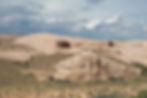
BUILDING STORMS. Rain clouds build over the Abajo Mountains (out of sight to the north) in this view of Cottonwood Canyon as seen from the edge of Tank Mesa. Photo: © Donald J. Rommes
The forecast called for scattered afternoon thunderstorms with brief periods of heavy rain. Flash floods were possible, but unlikely. I was more concerned about the clay roads I was driving on turning to gumbo—which would make them impassable until they dried.
I was driving the rutted dirt road in Butler Wash, about ten miles from the paved road. My plan had been to park somewhere along the road and hike up a section of Comb Ridge, but given the forecast of afternoon thunder and lightning, and the quickly darkening skies to the west, I thought better of it.
Instead, and on a whim, I turned east and followed a spur towards the top of Tank Mesa. Never having been there before, I wondered what it was like. Besides, I thought, the eastern border of Tank Mesa was Cottonwood Canyon, maybe there was a way to access the middle of the canyon this way?

WESTWARD TO THE COMB. On the two-track road, about one mile from Cottonwood Canyon, which is behind me. This photo, taken from my parked truck, looks west. The sandstone crest of Comb Ridge peeks above the western horizon. Photo: © Donald J. Rommes
As the road climbed the western slope of Tank Mesa, the sandy surface turned to clay and my concerns about gumbo were rekindled. Behind me, clouds continued to slowly build over Comb Ridge. I estimated I had at least a few hours before the rain fell—plenty of time to find a route into Cottonwood Canyon.
A couple of turns later, I was following a little-used sandy two-track eastward, The edge of the Mesa looked to be only a mile away and, since I wasn't sure I could turn the car around beyond this point, I parked and continued on foot.
After half an hour of walking, the sandy soil was replaced by slickrock. A short while later, I reached the edge of the mesa and could look down into Cottonwood Canyon.
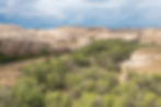
COTTONWOOD CANYON. Looking southwest down Cottonwood Canyon from the eastern edge of Tank Mesa. Cottonwood trees line the course of the intermittent creek in the wash. Photo: © Donald J. Rommes
After a few minutes of scouting, I discovered what appeared to be an old horse trail that descended a steep ramp of stone to the floor of the canyon. The clouds were darker but there was no thunder as yet, so I gave myself an hour to explore.
Rock art is, by definition, on rocks, so I headed for the walls of the canyon to search for some. I chose a couple of spots that had good exposure to the canyon, because the Ancestral Puebloans who lived here seemed to want their rock art symbols visible. I climbed a few sandy benches to get out of the wash and closer to the walls. The first two places I looked were blank. I followed the third wall for about 50 yards before I found petroglyphs. They were part of a larger panel, about twenty yards in length, and hidden by bushes (that probably were not there 1,000 years ago).

GEOMETRIC GLYPHS. Petroglyphs, presumably from the Basketmaker period, at eye level along a sandstone cliff face with a good view of the canyon. They are not easy to see because of the degree of re-patination. Photo: © Donald J. Rommes
The glyphs were mostly geometric shapes. The gouges comprising the petroglyphs were smooth and largely re-patinated—consistent with great age, I took a few photos and moved further down the wall, Soon, a deep gully cut into the sandy terrace hugging the cliff face and I was forced back down to wash level.
A hundred yards further down canyon and on top of the sandy terrace, a huge sandstone boulder had separated from the cliff face. To its right, the smooth cliff face had a thin coating of desert varnish—a good place to look for glyphs. I scrambled up the dune to the cliff face but saw no glyphs, However, behind the huge boulder to my left was a wall of stacked stone that closed off the dark void between the boulder and the cliff face. A small entryway led inside.

BETWEEN BOULDER AND CLIFF. The masonry wall closing off the space between the boulder and the cliff face. The large boulder on the left and beyond the wall sits on a high dune. That dune drops off steeply to the boulder's left and in front of the camera to reach the level of the wash. The small "doorway" controls access to a sloping space of uncertain utility that also drops steeply to the wash. Photo: © Donald J. Rommes
As usual, I found more than I anticipated. I was tempted to explore further down canyon but the darkening skies persuaded me to turn back. Rain was falling in many places to the west, but in the dry climate, it didn't reach the ground (Virga). Nevertheless, the falling rain drops of the Virga were caught by the golden light of the setting sun as it neared the crest of Comb Ridge. By the time I had descended Tank Mesa and reached Butler Wash, a double rainbow had formed—a good sign I would make it back safely to my motel that night.

GLOWING VIRGA AND DOUBLE RAINBOW. In the vicinity of Butler Wash, rainclouds pour over Comb Ridge and Virga catches the golden light of the setting sun. A double rainbow forms and stays put for 10 minutes until it is extinguished by heavy rain. It is only a few minutes to the paved road from here. Photo: © Donald J, Rommes
For more of Cottonwood Canyon, please see the small gallery of Cottonwood here.